Hikers with ID
Matching each hiker with the right trails can help hiking planners and partners to find the perfect hike.
How can I find trails now?
A detailed inventory of hikes in our region reveals just how overwhelming the choices are for beginners
How are trails rated?
The criteria for rating trails of varying levels of difficulty are not that useful to beginning hikers with ID!
Access adventure
Using existing data to carefully cali- brate hikes that help beginning hikers grow over time into adventurous ones.
Building a trail inventory
Applying progressive access to the inventory of trails in our region reveals a wealth of great options.
Evidence-based practices
How can you adapt core EBPs identified for other skills and behaviors to hiking?
A community of hikers!
Imagine creating new social connections, and building a regional trail inventory together!
Coming soon
Building a regional trail inventory
Distinguishing between baseline, beginner, and more adventurous hikes helps to organize your data and scale up your regional trail inventory
March 31, 2020
Late afternoon at Flint Woods Progressive access helps us to re-think which trails are best suited for hikers who just getting started, for hikers who want to build their capacity, and for hikers eager for even more adventure. As it turns out, these three phases are also really useful in shaping the creation of a trail inventory, because they help us start by drawing on the kind of data that are most likely to be readily available. Just as a hiker can work progressively towards becoming more adventurous, a regional hiking coordinator can work work progressively towards assembling the inventory to support hikers and their partners.
For those about to try their first hike, or beginning to build their capacity, this kind of inventory is really important. Consider a new hiker in our own region: instead of trying to choose between the 70+ trails listed within a 30 minute drive, we can start with a trail that we are sure will meet our needs. This confidence can help dispel some of the anxiety about trying something new.
This page is aimed at regional hiker coordinator who want to assemble a trail inventory. We begin by describing the three broad levels of hikes, each with their own map. We end with technical guidance about how to actually create the inventory and accompanying maps. We are ready to provide whatever support might be needed to replicate this effort elsewhere.
Sample Guidelines

 Kennett Square Trails

Making hay at Cheslen
Interested in becoming a regional trail coordinator, and creating maps like this for hikers near you? Email me and I will walk you through all of the steps. Let's get everyone hiking!
Phases of trails
Phase I: Easy trails to establish a hiker's baseline
Our first goal is to map out trails that can help hikers establish their baseline: how far can a new hiker comfortably cover in at least 30 minutes, but preferably 60 minutes. To control for as many factors as possible, you need flat trails that are paved or have a hardened hardened surface. You should aim to identify at least 3-5 such trails, to give hikers some choice. If you have more than 5 possible trails, list your favorites separately (as I did in the Kennett Square inventory).
Some other tips...
- I prefer loops that runs through a shaded forest preserve by a stream. A shaded trail can be enjoyed all year round (and may be the only trail you will enjoy on a sunny summer day), and trails by streams tend to be flat - like the Struble Trail.
- List trails in municipal parks separately, as these tend to be overused (I made an exception for the Brandywine Park Loop because the river views are great!).
- At this point, you must avoid any trails with any appreciable slope or steep sections. For trails listed in Alltrails, you should be careful of any trail with a total elevation gain of more than 100 feet per mile. Plotting elevation changes using the excel spreadsheet described below is, however, the only way to really be sure.
- You are unlikely to find interesting, flat, paved loops less than 1 1/2 miles in length, and so will likely have to identify good sections with longer trails. In this case, take care to identify where to start (as we did with the Brandywine Park Loop and the Struble Trail.)
- For now, just note the length of the trail in miles (if doing a section of a longer trail, just note "up to")
- Whenever possible, offer guidance about parking... Is there a parking or entrance fee? Are there alternate parking areas? Do the lots tend to get crowded?
Phase II: Trails for beginners that gradually increase in difficulty
The first step in this next phase is easy: review paved trails identified in the last step and identify those that allow for longer hikes. For the second (and all subsequent) steps, however, you will have to calculate the effort required for each hike. This includes a lot of technical stuff described later in this page... downloading existing GPX data into an excel sheet to calculate slope, and so on.
The effort score is key, as it allows hikers and their partners to feel confident that a new hike will be not be markedly more difficult than a familiar hike. The second step in Phase II requires that you identify paved trails or sections that are up to 2 miles long and that include with a sloped section (i.e., usually more than a 100' elevation change per mile).
The final step in Phase II requires that you identify wide trails, with a stable and even natural surface, up to 2 miles long. Determining the width and surface of the trail takes additional work. You may be able to make a reasonable guess through some detective work on specific trail listings in Alltrails.
 Alltrails MapLayersClick the Map Layers (to the right), change to satellite view. Mowed trails that stay within an open field or meadow, and that do not include sections that are most difficult, are good candidates. Most parks and preserves do mow trails regularly, and this plus normal traffic all but ensures a good surface, but you can also check the description and photos (next)
- Read the description, and check out the reviews and photos. Look for evidence of muddy or uneven sections. This might be enough to confirm that even a forested trail is wide enough. A trail that is at least 3 feet wide will give hikers an easy option to step around roots, rocks and some muddy sections, though this only works for hikers who do not need a partner directly beside them for guidance or support.
If you do not feel confident in the information you are getting from Alltrails, then you may need to make your own maps by walking the trail yourself.
Phase III: Trails for more adventurous hikers
Coming soon!!
Longer and larger trail systems
Longer trails - break into sections
Coming soon!!
Working with ScribbleMaps
Customizing a local guide
Other technical stuff
Organizing your data
An Alltrails list created using filters is certainly a start, but these filters do not include all of the variables needed to assemble a trail inventory. For that, you need a spreadsheet like Excel, and a regional trail coordinator who comfortable working with it.
The first spreadsheet is easy: it simply helps to organize your trails by broad categories to identify which trails to look at more closely. Begin with trails that are rated as easy, and that have a paved or hardened surface. Include a link back to the original Alltrails listing, as you may need to scan the description to see what the surface is (although that too can be unclear).
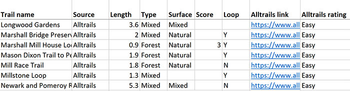 Even though I am very familiar with local trails, I found this list to be helpful in reminding me of trails I should consider. It also allows me to add trails that are not in Alltrails - in fact, 20-30% of my favorite trails were not listed. At this point, I like to also note the type of trail: whether it is a forest, or meadow, or mixed, and whether it is a loop. I also note if this is in a city park. I find that city parks tend to be more crowded, while a forested loop in a nature preserve is likely to be more peaceful and interesting.
Downloading data into Excel
Coming soon!
Calculating Slope: Other Details
Calculating slope from existing GPX data is tricky. Measuring changes in slope from 1 data point to another can magnify errors inherent to GPX data, so we used several techniques to smooth these. For example, we calculate changes in elevation over overlapping 1o0' sections. Elevation changes over a half-mile cannot simply be calculated by measuring elevation at the beginning and the end. For example, a downhill section can mask a steep - and more difficult - uphill section. So we calculated average slope only using increases in elevation across overlapping 100'sections, and only for half-mile segments with at least 1/3 of 100' segments that are either flat or positive in slope.
The next step is more complicated: it involves importing GPX data into a purpose-built Excel spreadsheet to automatically calculate changes in slope and assign effort ratings to each 100 foot section and 1/2 mile segment. This is important: while an amateur to differentiate a flat from a steep section of trail, they cannot make more subtle distinctions. Is this just a steeper section, or a change in overall slope for an entire 1/2 mile segment? For hikers like Margot, subtle changes in slope across an half-mile, or more significant changes for a section, can make the difference between a comfortable and an uncomfortable hike. Whether I download an existing GPX file or a trail that I recorded myself from Alltrails into Excel, it takes about 15 minutes to align these data to generate the effort scores for a trail.
Mapping your trails
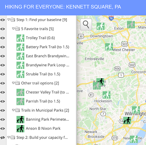 For now, I create Google Maps to generate maps that list a range of trails, as well as maps for individual trails yet to be listed on Alltrails. While I may shift to other apps, Google maps is a good place to start, as it is familiar to most users, and offers a basic functionality. For example, our map of trails for beginners (to the right) allows us to include links back to this website for more information, and include different layers for different stages. The listing for a given trail allows us to include a link back to a trail map (either on Alltrails or our own Google map), other useful information (including the overall effort score), and offer an easy way to get directions to the trailhead. I like to include pictures of Margot on this trail, to show that you too can walk it!.
Click on right-facing triangles to close folders and shrink the menu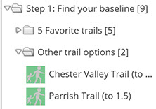 Click on downward-facing triangles to open folders to expand the menu, and then click on the icon to see more information on the trail.
![]() Click here to show these trailsClick here to hide these trailsScribble Map Tips
Click here to show these trailsClick here to hide these trailsScribble Map Tips
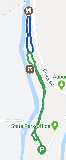 A map for the trail itself is also very useful. Trails created through Google maps or already available on Alltrails allow you to follow your route in real time, and make sure that you are in fact on the right path, and are making the progress you expected. Like the map for the Trolley Trail and Extension (to the right), these maps also allow you to include other waypoints and photos conveying other useful information, like the parking area, places to sit, and other interesting things to see.
Add photos and waypoints when you create your own trails
Include resting areas
Previous
Our Solution: Progressive access
Progressive access uses data to guide planners in selecting regular 60 minute hikes that are calibrated to gradually build the capabilities of hikers to take on more and more challenging trails.
Next
Evidenced-based practices for hikers
Core EBPs identified as effective for teaching other skills or preventing problems in people with ASD can be readily adapted to building hiking skills and endurance for those with ID.
Coming soon
Design by Jeremy Goldberg
Muse-Themes.com
The logo is adapted from Joaquim Alves Gaspar's drawing of Pedro Reinel's compass rose.
Connect
Hikers with ID
Matching each hiker with the right trails can help hiking planners and partners to find the perfect hike.
How can I find trails now?
A detailed inventory of hikes in our region reveals just how overwhelming the choices are for beginners
How are trails rated?
The criteria for rating trails of varying levels of difficulty are not that useful to beginning hikers with ID!
Access adventure
Using existing data to carefully cali- brate hikes that help beginning hikers grow over time into adventurous ones.
Building a trail inventory
Applying progressive access to the inventory of trails in our region reveals a wealth of great options.
Evidence-based practices
How can you adapt core EBPs identified for other skills and behaviors to hiking?
A community of hikers!
Imagine creating new social connections, and building a regional trail inventory together!
Coming soon